The safety issues surrounding the UK’s network of level crossings are well documented and with no current live closure resource available, finding a closed level crossing on your route can also be huge inconvenience. The development of Level Crossing Countdown appl hopes to address some of these issues.
Interested in its development?
See our Contact page...


Why is a Level Crossing App needed?
the problem with level crossings...
Encountering a closed level crossing on your journey can be very inconvenient, especially if it’s along a route taken on a regular basis. The queuing traffic caused by a closed level crossing can contribute to both noise and air pollution, as well as causing a nuisance to local residents. Level crossings are also a well documented safety hazard.
The UK has over 6,500 level crossings, including footpath crossings. At present there is no resource available to UK residents that details the live closures and locations of the countries network of barrier and gated road level crossings, and footpath crossings.
The Level Crossing Countdown iPhone application hopes to address these issues. Using GPS technology and level crossing closure schedules, it displays the status of the crossing(s) along your planned route. This information allows you to plan the departure or course of your journey accordingly.
With safety in mind, the LCC application will also display and warn you of level crossings in your immediate vicinity.

Potential Benefits
Saves Journey Time
Be aware of level crossing closures on your planned route and schedule your departure or path accordingly.
Increased Awareness
Locate level crossings in unfamiliar territory, with PUSH notifications to warn you when you are nearing their viscinity.
Reduces Accidents
Users may avoid or will be more aware of level crossings on their chosen route. This could result in less traffic and pedestrians approaching both road or footpath crossings during train usage times and reducing accident cases.
Frustration Reducer!
Nobody likes queueing at a closed level crossing. Having prior knowledge of closure times will reduce driver, cyclist and pedestrian frustrations.
Reduced Polllution
With less traffic approaching level crossings during closure times, there will be a reduction in the air and noise pollution caused by queueing vehicles.
Headphones Distraction?
As a pedestrian, listening to headphones can prove a major safety hazard around level crossings. The LCC App has the potential to cut the iPhone headphone feed when the user enters into the vicinity of a train level crossing.
Locate Crossings
launching
Upon launching the application you are requested to authorise GPS location services to confirm your current location. This information is required to find level crossings that are in your immediate surrounding area.
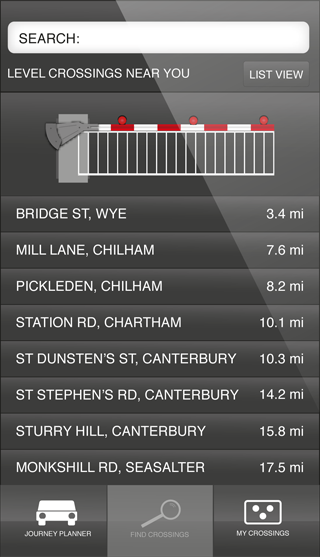
crossing list
The application lists level crossings by road name and their city, town or village in order of their distance from your current location. Alternative locations can be found using the SEARCH facility.
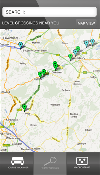
map view
Switching to MAP VIEW will display the locations of all listed crossings on a map graphic. The level crossing you are interested in finding out the status of can now be selected...
Crossing Status
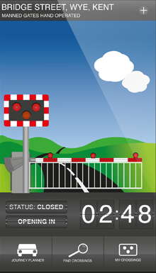
your selected crossing is 'closed'
The level crossing you have chosen is currently closed. The application shows the barrier down and the red signal warning lights are flashing. A scrolling countdown displays how many minutes until the crossing opens again. Pressing ⊕ next to the location of your chosen crossing will list it within MY CROSSINGS; level crossing that you are likely to require the status for on a regular basis.
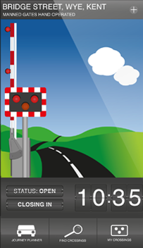
your selected crossing is 'open'
The level crossing you have chosen is currently open. The application shows the barrier raised and the red signal warning lights are inactive until the next closing time approaches. A scrolling countdown displays how many minutes until the crossing closes again. Information on the type of level crossing is also available to the user.
will the crossing status affect my journey?
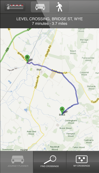
Navigating to JOURNEY PLANNER within the application will show your current distance from your last selected level crossing (using a Google Maps API). Selecting the BY CAR or WALKING buttons displays how long it should take you to reach the crossing with either of these chosen methods of transportation. With these journey details, plus the countdown clock information, you can estimate whether there is likely to be a train crossing your path during your planned journey.

Contact - Your Interest
The proposed Level Crossing Countdown iPhone app is currently in development. If you are interested in being a part of the project, or would like to download the finished app, please complete this form.